— Resources for Researchers
Getting Started
IPEN Adult Research Study Aims
The primary aim of the IPEN study is:
- To estimate strengths of association between detailed measures of the neighborhood built environment with leisure physical activity, walking/cycling for transportation, and BMI in all participants, based on self-report survey data collected according to a common protocol.
The secondary aims of the IPEN study examine the same questions as the primary aims, but use objective measures in a smaller sample of participants:
- To estimate strengths of association between detailed self-report measures of the built environment, based on standardized surveys, with total physical activity, based on objective monitoring with accelerometers.
- To estimate strengths of association between detailed individual-level objective measures of the built environment around each participant’s home address, using 1000m and 500m network buffers created in GIS, with self-reported overall leisure physical activity and walking (and cycling) for transportation purposes.
- To estimate strengths of association between detailed measures of the built environment using GIS, with BMI and total physical activity, measured objectively with accelerometers.
- To create indices of self-reported measures of mixed land use, neighborhood walkability, access to recreation facilities and public transportation, aesthetics, traffic safety, and crime safety, that optimize explanation of physical activity and BMI in pooled analyses, so these indices can be recommended as international standards of measurement.
Read the IPEN Adult Protocol Paper here published in Journal of Physical Activity and Health
IPEN Adolescent Research Study Aims
The primary aim of IPEN Adolescent is:
To estimate strength, shape, and generalizability (across cities) of associations of objective (GIS-based) and reported measures of the community environment with accelerometer-measured minutes of moderate-to-vigorous physical activity (MVPA) and sedentary time, along with multiple reported physical activity indices in adolescents aged 11-19, from data collected according to a common protocol in 15 countries.
Secondary aim of IPEN Adolescent is:
To estimate strength, shape, and generalizability of associations of objective and reported measures of community environments with overweight/obesity in adolescents.
Tertiary aims are to examine:
The unique contribution of objective and reported measures of built environment attributes to explaining physical activity, sedentary behavior, and weight status in adolescents.
Mediating effects of objectively measured MVPA and sedentary behavior on the relation between objective and reported environment attributes and weight status.
Moderating effects of neighborhood socioeconomic status and sex on the relation between objective and reported community environment attributes and physical activity, sedentary behavior, and weight status outcomes.
The combined and interactive effects of psychosocial variables (social support, self-efficacy, barriers), home environment variables (sport equipment, electronics), and community environment variables in explaining physical activity and sedentary behaviors.
Read the IPEN Adolescent Protocol Paper here published in BMJ Public Health
What is Walkability?
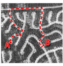
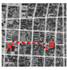
Some may think of “walkable” neighborhoods as areas people enjoy walking. Certainly there may be environments that encourage leisure time walking. However, the “walkability” concept employed in the IPEN project methodology is different. It comes from the transportation and urban planning fields and is concerned with environments that primarily encourage people to walk or bike for transportation. “Walkable” neighborhoods in this context are ones where it is easy to walk or bike directly to multiple destinations. Hence, two important factors in the “walkability index”(used to select neighborhoods for IPEN studies) are street connectivity and mixed land use: schools, homes, offices, and shops are all within easy reach of each other in a given area.
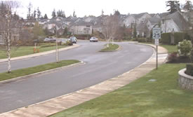
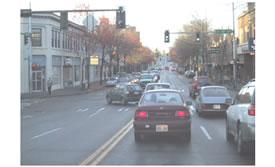
The photos below illustrate this point. Some may think Photo A shows a walkable neighborhood, with sidewalks and greenery. But in transportation terms it is less walkable as there are no destinations to walk or bike to. It is isolated and disconnected from other places to go. Photo B is a more walkable neighborhood as there are many roads leading to many different destinations.
Low Walkability

High Walkability

Low Connectivity

Illustration: Greenwald, M.J. Transportation Research Record 2001
High Connectivity

Illustration: Frank, L.D., ‘Health and Community Design’
What is GIS?
One of the most daunting parts of environmental research can be learning about Geographic Information Systems (GIS) and Census data. GIS is computer software that links geographic information (where things are) with descriptive information (what things are like). Unlike a flat paper map, where “what you see is what you get,” GIS can have many layers of information. Each country (in fact, most cities) will have different databases with varying levels of detail.
It will be helpful to find not only a technical GIS expert in your region but someone who can help make sense of GIS data in the context of urban and transport planning. Leadership for GIS methods for both Adult and Adolescent studies at the coordinating center were led by Larry Frank and Jim Chapman of Urban Design 4 Health, along with Marc Adams.
Arc View is useful software for working with GIS data. There are many resources and tutorials for this software online.
The following are useful web links to help get started:
www.esri.com
www.mapcruzin.com/what-is-gis.htm
www.amazon.com/exec/obidos/ASIN/0130460273/103-0572758-507663
www.fhwa.dot.gov/tfhrc/safety/pubs/vol2/sec2.18.htm
Examples of GIS maps:
Federal_way_zoomin.wmf
Queen_anne_zoomin.wmf
Establish an Interdiciplinary Team
The first step in developing and planning a physical activity and environment study is to form an interdisciplinary team. It is important to work with experts in the following fields:
- City/Urban planning
- Transport
- GIS
- Architecture
- Behavioral science
- Policy makers
- Leisure
GIS has been used with great success in physical activity and environment studies, both published and forthcoming. While GIS is a technology that produces excellent, objective data on environmental attributes, the challenge is to turn these data into meaningful information. This is where, particularly for behavioral scientists, epidemiologists, and other ‘non-spatial’ researchers, collaborations with researchers from ‘spatial’ disciplines are crucial. For example, in public health research, behavioral scientists, epidemiologists, demographers, and experts from other disciplines have begun to study the spatial determinants of health-related behavioral choices. In transportation and urban planning, researchers from social geography, urban studies, architecture, transport engineering, and other disciplines have conducted studies on how urban form can influence active or inactive commuting choices. In leisure studies and related areas, researchers have built a broad body of knowledge, concepts, and methods relating to active uses of leisure time in parks, on trails, and in community facilities. These disciplines are now coming together and finding new common ground.
A key objective of IPEN is to encourage the interdisciplinary linkages that will allow the best behavioral, social, and spatial data to be gathered. The following link is to key publications that are useful for understanding the nature of transdisciplinary research: Transdisciplinary_research_references.pdf
Build on studies from other countries
While we recognize that each country will have unique environments for which specialized measures may need to be developed, we strongly encourage countries to build upon existing work and to strive for comparable measures wherever possible.
- IPEN methods have now been tested in several English speaking countries including the UK, US, Australia and New Zealand. English speaking countries should review materials from these studies and employ as many existing materials as possible. Even across English speaking countries there can be language differences. We were able to modify and add to the Neighborhood Environment Walking Scale (NEWS) items for use in the Australia setting. For example, in Australia we do not have ‘condominiums’, but we have ‘blocks of flats’; we have no ‘sidewalks’, but we have ‘footpaths’; etc. Importantly, we employed the majority of the NEWS scale items. We can now make close comparisons between the USA and the Australian findings.
- Three countries in Latin America (Brazil, Colombia and Mexico) are collecting IPEN data. They have collaborated to ensure a common survey of typical local environments.
- Several countries have bicycling environments that are more sophisticated that the US. They have collaborated to assess bicycling environments uniformly across countries.
- The ALPHA project in Europe has developed a European version of the NEWS.
Institutional Review Board (IRB) Issues
There are 2 key IRB issues regarding human protection in IPEN research:
- For IPEN research involving human subjects, formal institutional review from each university’s IRB or Human Protection committee is necessary to ensure and document that all research procedures comply with human protection standards.
- In addition, for all countries that provide data for inclusion in the IPEN pooled analyses, country investigators and their key personnel participating in the research process must also complete the San Diego State University (SDSU) human protection certification process in compliance with NIH and SDSU guidelines.
IRB (human protection) protocols typically are comprised of several categories of information about the research and procedures involving human participants. Sections usually include:
1. Risk to Human Subjects
a. Human Subjects Involvement and Characteristics
- Background. Includes a brief review of relevant literature, description of IPEN research, and the study’s primary and secondary aims.
- Study design and methods. Description of the proposed IPEN study design and data collection methods as adapted from those that have been used in three US NQLS studies and the PLACE study in Australia. Include the main principle of selecting specific study neighborhoods within each country to provide a large range of variability in built environments, with neighborhood selection based on identifying high- and low-walkable neighborhoods in 1 or 2 cities in each country, and defined using an adaptation of the walkability index (e.g., including household density, street connectivity, and mixed land use).
- Participant selection and recruitment. Within the identified neighborhoods, describe how participants will be identified and recruited. For example, recruitment may be done by mail, phone, or face to face, depending on what works best in the country.
b. Sources of Materials
This section provides more detailed information about the research materials that will be used in the study; e.g., typically involving three categories of data: (a) land use information (preferably objective GIS data) related to the physical environment and “walkability” of selected neighborhoods in each country, (b) objectively assessed physical activity measured using accelerometers worn by individual participants selected from the neighborhoods in the study, and (c) self-reported survey data on physical activity and psychosocial correlates of physical activity, including participants’ perceptions of environmental factors. Any additional variables to be measures should also be described here, such as psychosocial, demographic, or health variables, as long as the participant burden does not threaten recruitment rates and the additions are affordable and approved by the institution’s IRB.
c. Potential Risks
Potential risks to study participants are typically minimal in IPEN research. Primary outcome measures of self-reported physical activity and overweight/obesity, as well as the objective physical activity measure, pose essentially no risk other than possible psychological discomfort associated with disclosing certain behaviors, attitudes, or feelings, or slight inconvenience related to wearing the accelerometer. The survey does not require participants to reveal highly sensitive information.
2. Adequacy of Protection against Risks
a. Recruitment and Informed Consent
A description of the procedures that will be used to identify and recruit participants should be described here. Describe the process of obtaining informed consent to participate in the study. Include inclusion and exclusion criteria, as well as any participant incentives for participating in the research
b. Protection Against Risk
Describe procedures implemented to minimize any risks to participants. It may be useful to mention that international investigators and key personnel will complete the SDSU IRB online certification program to ensure that NIH and SDSU standards for IRB human protection are being met. In addition, all proposed measures have been used successfully in previous research with no negative effects. File naming and participant ID protocols that protect individual identity should be described. Data and participant materials should be stored securely to ensure participant confidentiality and privacy. Participants should also be assured that data are for research purposes only and that findings will only be presented in aggregate form. No identifiable information on individuals will be used in reports or manuscripts.
3. Potential Benefits of the Proposed Research to the Subjects and Others
a. Benefits to individuals
Typically, the only benefit to individual participants is a small incentive for completing all the requested measures.
b. Benefits to science, society, and humanity in general
Physical activity and obesity control are priority areas in the health promotion and disease prevention objectives. Briefly mention how this study will broaden the understanding of potential influences on physical activity and weight control to include pervasive macro-environmental variables that can be modified by public policy. Results can also inform public health, land use, and transportation policies that could have population-wide impacts on a relatively permanent basis. Any information that might be used to increase people’s physical activity and control obesity could have important implications for preventing or delaying the development of cardiovascular disease, cancers, diabetes, and other physical and mental health conditions.
4. Importance of the Knowledge to be gained
Numerous US and international agencies have identified environmental and policy interventions as the most promising strategies for improving physical activity, eating, and obesity control. However, accurate effect sizes are needed to judge the relative importance of the built environment and provide useful guidance to decision makers and designers who can translate research into policy and practice. International research using a common design and measurement protocol examining diverse built environments should help produce more accurate effect size estimates.
